
Mülheim-Kärlich: Orchards, Trails and History
Accommodation in Mülheim-Kärlich
Fruit trees, scenic trails and traces from different centuries give Mülheim-Kärlich its distinctive character. You can get to know the town through its fruit-growing culture, combine a hike with panoramic views, or explore Roman finds and local architectural history. Which of these themes interests you most may also influence your choice of holiday apartment.
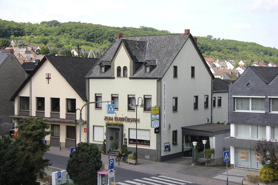 Historische Ortsansicht von Mülheim-Kärlich mit alter Gemeindehalle und dem Gasthaus „Zum Kurfürsten“ in der Burgstraße.
Photo: Lothar Spurzem via Wikimedia Commons, CC BY-SA 2.0 de
Orchard Trail and Cherry Blossom Paths
The orchard trail stretches across around 12,500 square metres on the slope of Rübenacher Berg. More than 50 different types of fruit are showcased there. The trail explains the characteristics of stone-fruit and pome-fruit trees, including peaches, rare apple varieties and elderberries. The cherry trees that help define Mülheim-Kärlich are also among the topics presented. The focus is therefore not on just one type of fruit, but on the diversity of local fruit-growing culture.
Andreas Anheier offers guided tours of the orchard trail at irregular intervals. If you would like to explore the trail on a guided tour, check locally for current options. There is a hikers’ car park at the starting point at Dalfter in the Kärlich district.
Another way to experience the orchards is the MK3 Cherry Blossom Panoramic Trail. It starts at the Nass playground by Hoorweiher in Mülheim, passes Lucasweiher and Lucas Mill, and follows the Lützelbach stream. It then runs along paved farm tracks through orchards and elderberry fields before returning to the starting point. The Streuobstwiesenweg (Orchard Meadow Trail), meanwhile, offers panoramic views of the Rhine Valley and the Volcanic Eifel. The two routes therefore have different emphases: named stops, the stream and fields shape the MK3, while views take centre stage on the Streuobstwiesenweg.
The MK5 Kärlicher Berg Trail leads from the hilltop through meadows with fruit trees to the southern edge of Kärlich. It follows a paved farm track past Sonnenhof and then heads west through orchards back to Kärlicher Berg. Those interested in raw-material extraction can explore a dedicated topic on the Kiesrundweg (Gravel Loop Trail), which offers insights into extraction between Mülheim-Kärlich and Urmitz.
Kärlicher Berg: Walks and Early History
Kärlicher Berg lies in the south of Mülheim-Kärlich at an elevation of 202 metres above sea level and is ideal for a long walk. The area is one of the most significant sites in western Europe for Ice Age animal remains and Homo erectus artefacts. Homo erectus is believed to have lived here more than 600,000 years ago. Information panels in front of the Bergheiligenhäuschen explain geological developments, archaeological finds and the economic use of clay. The landscape and the panels offer different ways to explore the same area: by walking through the orchards and by discovering its history.
Museum, Roman Villa and Churches
The Mülheim-Kärlich Town Museum was founded in 1985 and, since 2003, has shared the former fire station with a café. On display are a fully furnished school classroom and a shoemaker’s workshop from the first half of the 20th century. A visit therefore combines the history of the museum building with two vivid glimpses into everyday life in the past.
The Roman villa rustica was operated as an estate in the 2nd and 3rd centuries AD and was uncovered in 1983 during pumice extraction. Its restored wall remains are in the southern part of the town, stand up to 80 centimetres high and measure 70 by 35 metres. An ancient underfloor and wall-heating system from the 3rd century AD can also be seen there. The scale of the complex and its surviving heating system give the Roman site a different dimension from the smaller everyday objects in the town museum.
The churches also have their own architectural character. Maria Himmelfahrt in Mülheim is a three-aisled neo-Gothic hall church with a 60-metre-high tower. It was built from volcanic Krotzen stone, faced with tuff slabs. At the present church building of St. Mauritius in Kärlich, the history of the site goes back a long way; the church has remained there throughout. Another trace of the past is the hunting lodge, built around 1480 by Elector Johann II of Baden and destroyed in 1635 during the Thirty Years’ War.
Choose a Holiday Apartment Based on Your Interests
A simple question can help you choose a holiday apartment: would you like your stay to focus mainly on orchard trails and walks, or would you also like to explore the museum, churches and Roman archaeological site? Mülheim-Kärlich has 51 kilometres of cycle paths, including the Rhine Cycle Route. The town lies north of Koblenz and close to the Rhine Cycle Route. Check the details before planning a specific cycling trip. The topics you would like to combine can provide a practical guide when looking for suitable accommodation.
The wider Mayen-Koblenz destination offers further cultural and historical attractions: Genovevaburg Castle in Mayen was built in 1280 by Heinrich von Finstingen, Archbishop of Trier. Sayner Hütte is an anchor point on the European Route of Industrial Heritage and the only monument in Rhineland-Palatinate to receive this distinction.
Discover more destinations
Discover more destinations: Ettringen, Waldesch, Polch, Vallendar, Niederelz, Rüber, Virneburg, Wierschem
Back to the main travel overview: Mayen-Koblenz.

